3D-printed Prosthetic Costs Way Less Than Other Alternatives
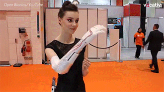

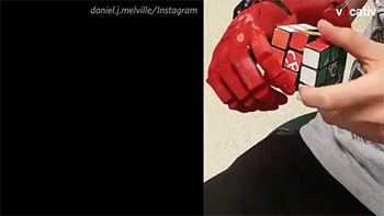
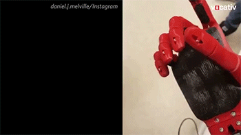
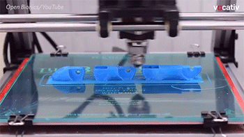

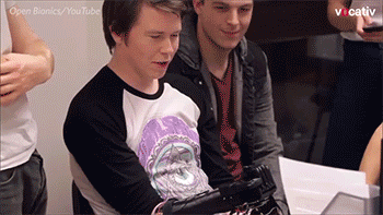
3D-printed prosthetic costs way less than other alternatives
Video
More Posts from Etreageometrievariable and Others


amen 🙏🙏🙏
Dare to date a GM 😊
I've accidentally misread it as "date a DM" and thought "oh my fuckin' god, YES!". Got slightly disappointed. And punched by my gf. Worth it.
“Date a DM” is pretty good advice that will lead to you usually having someone to run a game for you.
But “Dare to DM” is even better advice, because you’ll always be able to play an RPG if you’re the one willing to run it!
Anyway, I lolled.
Si je devais avoir du mépris
Si je devais avoir du mépris, ce ne serait pas pour l’ignorant, le fanatique, le passionné ridicule, pour les gens superficiels ou imbus d’eux-mêmes.
Si je devais avoir du mépris, ce ne serait pas pour le cracher à la tête de ceux qui ont une opinion différente de la mienne.
Si je devais avoir du mépris, ce ne serait pas pour ceux qui se comportent comme des cons aujourd’hui.
Non, si je devais avoir du mépris, ce serait pour ceux qui se comporteront comme des cons demain.
Ce serait pour ceux qui se pavanent plein de certitudes, certains de leurs connaissances inébranlables, de leurs sources irréfutables, de leur parole incontestable. Inamovibles colosses dont les théories sont étayées à grand renforts de données biaisées, d’extrapolations fumeuses, de faits mal analysés et de vérités partielles.
Pour ceux qui se font fort d’esquiver les questions gênantes avec la mauvaise grâce que caractérise une foi encore plus mauvaise.
Ceux qui refusent le dialogue en bâillonnant ceux qui les entourent. Ceux qui se créent des œillères pour ne contempler que ce qui leurs plait. Ceux qui s’assourdissent avec leurs propres discours, tels des disques rayés, ânonnant les mêmes paroles jours après jours.
Ce serait non pas pour celui qui n’est pas intelligent, mais pour celui qui refuse de l’être.
Car si l’intelligence est dans la nature de l’Homme, alors je ne vois pas de comportement plus aberrant que celui qui consiste à en refuser l’expression et le développement.
Oui, si je devais avoir du mépris, ce serait pour lui, pour elle. Pour toi aussi qui me lis. Pour moi, surtout.
Car l’idée même que l’immobilisme intellectuel est une plaie est une idée fixe. Sans doute s’appuie-t-elle sur les biais mentionnés plus haut.
Mais c’est la seule qui semble conserver la notion d’autocritique et de rigueur intellectuelle, et c’est sans doute celle qui confère à notre esprit le plus de vertu.
Idée de JdR (pitch)
2015: les USA n'ont pas pris part à la seconde guerre mondiale, le débarquement n'a pas eu lieu. Épuisée, l'Angleterre a rendue les armes, à la suite de quoi l'étreinte Nazi a étouffé toutes les poches de résistance en Europe. Contraints de fuir, des centaines de français trouvent refuge dans les colonies.
Pendant plus de 60 ans, le IIIème Reich s'est assoupi sur ses victoires passées. Mais l'appétit dévorant de ce géant autoritaire et militariste n'est jamais rassasié. Alors que ses yeux gourmands se tournent vers les restes de ses ennemis d'antan, les descendants des réfugiés de la guerre, craignent de revivre l'Horreur une fois de plus... Lorsque rafles, censures et raids anti-libertaires s'abattent à nouveau sur le Monde, le feu d'une révolte sans précédent s'allume... Le laisserez vous s'éteindre, ou brûlez vous de ce feu intense qui abat les dictatures?
Il y a sans doute pas mal d'objections historiques à apporter à ce pitch de base, mais l'idée m'a bien plus. Apparemment, je suis pas le seul, vu que j'ai déjà un joueur et deux joueuses qui se sont manifestés!

A note handed to the men guarding a prisoner we were trying to free…


Rappel cordial que les artworks de L5R = <3 (Et ceux de Mario Wibisono en particulier)

Bayushi Misaki by MarioWibisono


\⊙▽⊙/

THE WHOLE MAP
How much of your map you draw depends on you and your story. Start with what is important to the story and when you have time, you can draw maps for other places as well.
When you draw the main area, whether it be an island, a whole country, or just part of a country, start with the outline and geography. Draw the main borders, add some geography, and figure out its climate based on its position. I would suggest drawing borders within an area after drawing the geography, as rivers are often used as borders and they can help give your world a more natural look.
If you’re making up the whole world with all its land masses and whatnot, I would suggest creating one giant landmass, cutting it up, moving the pieces around a bit, and then adding and taking away some coastal lands to change the shape a bit.
When focusing on an area and with a story in which characters travel, it’s a good idea to figure out the distance so you know how far and how long your characters need to travel. To do this, compare the map to a real-world map and come up with a conversion for distance (ex: 1 inch = 15 miles).
If you have trouble coming up with borders, coastlines, rivers, mountain ranges, and other geographical and political locations, grab some maps or an atlas and trace small parts of real world places for your map. Put them all together and you’ve got a whole new world.
Stuff to Include:
Compass rose
Names of geographical places
Symbols to represent settlements
Bodies of water
Geographical places such as mountains and deserts
Important major roads
A legend for these symbols
The trail that your characters travel on
SETTLEMENTS:
If there are important settlements in your story, it’s a good idea to make a map for your own reference. Some settlements are (in order of smallest to largest): hamlets, villages, towns, and cities. Of course there are other settlements, but the terms used and what they mean vary by region.
Before you make your map, you should consider the following:
What is the population? How many people make up a village or a city is up to you and it should reflect the population and the population density of the fictional region you’re writing in.
Where is it located? The first permanent settlements started small and sprung into cities while farms and villages popped up around them. These settlements were also near water and other resources, which brings us to the age:
How old is it? The oldest settlements will be near water no matter how much technology is available in the time period you’re writing in. Older settlements were not built with the technology needed to transport water to far places. How old a settlement is will also affect the architecture and the artifacts and structures found nearby.
What is the layout? Newer settlements will typically have an organized layout based on the geography around the settlement. Older settlements may be organized as well, but are more likely to have roads built around permanent dwellings and buildings rather than the other way around. If your settlement is organized, build the roads first. If it’s not, mark structures first and build the roads around them.
Roads & Buildings:
Like mentioned above, the layout of your settlement depends on geography, roads, and structures.
It would be best to start with the geography, such as hills, bodies of water, and forests. Once you have the general geography of the settlement, you can either put the roads down or the structures.
Organized settlements should start with major roads. How many you have depends on the population size. If there are only a few hundred people in the settlement, there may only be one or two main roads with several minor roads. The main road should lead people to important areas of a settlement, such as a government building, the roads out of the settlement, and other non-residential buildings or structures. However, there can still be residential dwellings. The minor roads should come off the main road(s) can lead to anywhere from residences to parks. To differentiate between the main roads and minors roads, draw the main roads as thicker lines.
Unorganized settlements usually, but not always, start with the structures and without a plan of what this settlement will develop into. While organized and pre-planned settlements are more likely to cut into geographical areas rather than work around them. If your settlement has less grid-like roads and more random placements, start by placing all the structures of your town before drawing the roads.
These types of settlements will still have some type of structure. For example, non-residential buildings tend to be in one area with the occasional stay building. This is usually where a main road ends up. Residential buildings are more random. How far apart they are depends on the type of settlement and what the people at that residence do. Farmers will have more land while those who don’t work off the land or who work outside of their home may or may not have smaller properties.
Draw the oldest roads in unorganized settlements first. The oldest roads usually end up being major roads whether they are straight or curved. The minor roads will go next or there may be no minor roads at all.
Now you have to name your roads and buildings. You don’t have to name all of them, but it can help for reference and it can help build your world.
If you are building a city rather than a smaller dwelling, there are more tips for that here.
GEOGRAPHY:
Climates and Ecosystems:
World Climate Zones
World Biomes
Tundra
Tundra Biome
Taiga
Grasslands
Grassland Biome
Chaparral
Savanna
The Mediterranean Biome
Forests:
Deciduous Forest Biome
Forestry Terms
Tropical Rain Forests
Temperate Forest
Forest Biome Regions
The Forest Biome
Sand:
Deserts
Anatomy of a Beach
Types of Dunes
Desert Biome
The Formation of Deserts
How Are Deserts Made?
Where Are Deserts Found?
Caves:
Caves
Cave Terms
Sea Caves
Solution Caves
Volcanoes:
Anatomy of a Volcano
How Volcanoes Work
Water:
Waterfall Classification
River Anatomy
Anatomy of a River
How Rivers Are Formed Animation
Freshwater Biome
Marine Biome
Lake Origins
Water Geography
Mountains:
How Mountains are Formed
Mountain Ranges
The Alpine Biome
Alpine
More:
Nations and Culture 2.1: Giving Land a Face
Fantasy World Maps
Glossary of Geography Terms
Fantasy Map Photoshop Resources
Fantasy Map Brushes
-
 the-promised-wlan reblogged this · 9 months ago
 -
 headlesssamurai liked this · 10 months ago
 -
 sapphire2309 liked this · 1 year ago
 -
 undeadobscurities liked this · 1 year ago
 -
 bobombbb liked this · 1 year ago
 -
 colinkloecker liked this · 1 year ago
 -
 giraffe-that-cries-strangely liked this · 1 year ago
 -
 scrytpe liked this · 1 year ago
 -
 thepheonixqueen reblogged this · 1 year ago
 -
 empty-blog-for-lurking reblogged this · 1 year ago
 -
 lookforanewangle liked this · 1 year ago
 -
 freya1022 liked this · 1 year ago
 -
 void-tiger reblogged this · 1 year ago
 -
void-tiger liked this · 1 year ago
-
 headspacedad reblogged this · 1 year ago
 -
 rosadavidii liked this · 1 year ago
 -
 qualityseabunny liked this · 1 year ago
 -
 frecklenog reblogged this · 1 year ago
 -
 sims3-dh liked this · 1 year ago
 -
 theblackcat reblogged this · 1 year ago
 -
 thelastmadarfakarrr liked this · 1 year ago
 -
 i-j0s liked this · 1 year ago
 -
 dippindotssz liked this · 1 year ago
 -
 inconstantsearchofperfection reblogged this · 1 year ago
 -
 stupidplan liked this · 1 year ago
 -
headlesssamurai reblogged this · 1 year ago
-
 petrichorparacosm liked this · 1 year ago
 -
 fantasymusic liked this · 2 years ago
 -
 iwillhaveamoonbase liked this · 2 years ago
 -
 nocathasfuture reblogged this · 2 years ago
 -
 darksyde63 liked this · 2 years ago
 -
 rollingviking liked this · 2 years ago
 -
 awstens-vagina liked this · 2 years ago
 -
 pilibdc liked this · 2 years ago
 -
 musdomus reblogged this · 2 years ago
 -
musdomus liked this · 2 years ago
-
 the-ghost-lanturn liked this · 2 years ago
Yet another geeky guy on the internet of Things. Plot-twist: is actually a feminist, expect some reblogs.
96 posts