Contrastes.
Contrastes.


100 views of Tokyo, Shinji Tsuchimochi
More Posts from Ritasakano and Others
Silk leaf
http://www.dezeen.com/2014/07/25/movie-silk-leaf-first-man-made-synthetic-biological-leaf-space-travel/

Women’s Activities
Artist: Ogata Gekko 尾形月耕 (1859-1920) Ink and color on silk Japan 1868-1912 Meiji era Freer Gallery of Art and Arthur M. Sackler Gallery
Muito bom!!

Resist the road-rage on the protein super highway.
Be sure to check out all our science GIFs here for your studyblrs, teacher websites, presentations, or mind-numbing entertainment! Just please keep our name on there and don’t sell them! :D
Fantástico!!

What’s that green streak in front of the Andromeda galaxy? A meteor. While photographing the Andromeda galaxy last Friday, near the peak of the Perseid Meteor Shower, a sand-sized rock from deep space crossed right in front of our Milky Way Galaxy’s far-distant companion. The small meteor took only a fraction of a second to pass through this 10-degree field. The meteor flared several times while braking violently upon entering Earth’s atmosphere. The green color was created, at least in part, by the meteor’s gas glowing as it vaporized. Although the exposure was timed to catch a Perseids meteor, the orientation of the imaged streak seems a better match to a meteor from the Southern Delta Aquariids, a meteor shower that peaked a few weeks earlier
Object Names: Andromeda Galaxy
Image Type: Astronomical
Credit: Fritz Helmut Hemmerich
Time And Space


Ernst Haeckel’s “Paleontological Tree of Vertebrates” (c. 1879).
Assustador!!
How Do Hurricanes Form?
Hurricanes are the most violent storms on Earth. People call these storms by other names, such as typhoons or cyclones, depending on where they occur.

The scientific term for ALL of these storms is tropical cyclone. Only tropical cyclones that form over the Atlantic Ocean or eastern and central Pacific Ocean are called “hurricanes.”

Whatever they are called, tropical cyclones all form the same way.
Tropical cyclones are like giant engines that use warm, moist air as fuel. That is why they form only over warm ocean waters near the equator. This warm, moist air rises and condenses to form clouds and storms.

As this warmer, moister air rises, there’s less air left near the Earth’s surface. Essentially, as this warm air rises, this causes an area of lower air pressure below.

This starts the ‘engine’ of the storm. To fill in the low pressure area, air from surrounding areas with higher air pressure pushes in. That “new” air near the Earth’s surface also gets heated by the warm ocean water so it also gets warmer and moister and then it rises.

As the warm air continues to rise, the surrounding air swirls in to take its place. The whole system of clouds and wind spins and grows, fed by the ocean’s heat and water evaporating from the surface.
As the storm system rotates faster and faster, an eye forms in the center. It is vey calm and clear in the eye, with very low air pressure.

Tropical cyclones usually weaken when they hit land, because they are no longer being “fed” by the energy from the warm ocean waters. However, when they move inland, they can drop many inches of rain causing flooding as well as wind damage before they die out completely.
There are five types, or categories, of hurricanes. The scale of categories is called the Saffir-Simpson Hurricane Scale and they are based on wind speed.

How Does NASA Study Hurricanes?
Our satellites gather information from space that are made into pictures. Some satellite instruments measure cloud and ocean temperatures. Others measure the height of clouds and how fast rain is falling. Still others measure the speed and direction of winds.

We also fly airplanes into and above hurricanes. The instruments aboard planes gather details about the storm. Some parts are too dangerous for people to fly into. To study these parts, we use airplanes that operate without people.
To learn more about how we study hurricanes, visit: https://www.nasa.gov/mission_pages/hurricanes/main/index.html
Make sure to follow us on Tumblr for your regular dose of space: http://nasa.tumblr.com.


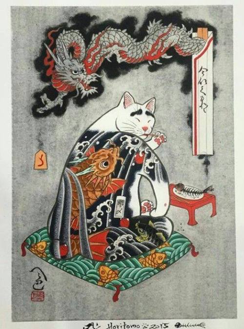

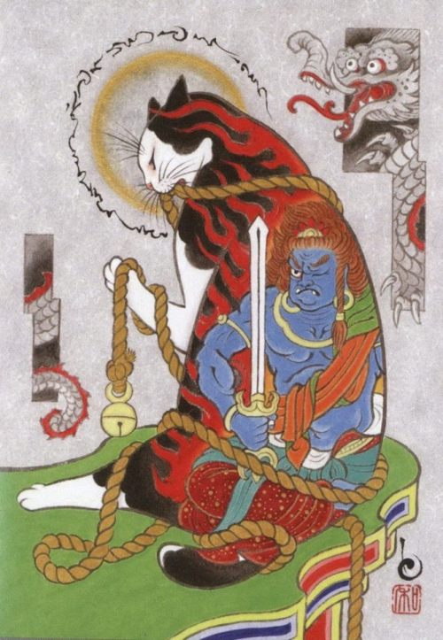


kazuaki horitomo’s tattooed cats.
-
 soothesoothesoothe reblogged this · 4 months ago
 -
soothesoothesoothe reblogged this · 4 months ago
-
 mothedrireblogs reblogged this · 8 months ago
 -
 kouryuudielysion reblogged this · 10 months ago
 -
 midnightwerewoolf reblogged this · 11 months ago
 -
 trip-of-memories reblogged this · 1 year ago
 -
 jetslingspeakiv liked this · 1 year ago
 -
 arumine liked this · 1 year ago
 -
 blastoffitspartytime reblogged this · 2 years ago
 -
 severeeggssludgesoul liked this · 2 years ago
 -
 jelloworld reblogged this · 2 years ago
 -
 kiokari liked this · 2 years ago
 -
 tealdandelions reblogged this · 2 years ago
 -
 mevil liked this · 2 years ago
 -
 cute-alma123 liked this · 2 years ago
 -
 vulpixtual reblogged this · 2 years ago
 -
 thirstyforfluff liked this · 2 years ago
 -
 mojozozozozomojo liked this · 2 years ago