Watching Water In The West
Watching Water in the West
If you’ve eaten a piece of fruit, a vegetable, or a handful of nuts in the past week, it’s very likely they all came from “America’s Salad Bowl.” California’s Central Valley and Central Coast is where more than one-third of all vegetables in the U.S. are grown––and two-thirds of our fruits and nuts.

Keeping this area fertile takes a lot of water, and we provide farmers with NASA data that helps them manage increasingly scarce supplies. Working with farmers and conservation groups, we developed a new website called OpenET to transform how water is managed in the West! It covers 17 western U.S. states, putting satellite and other Earth science data into their hands. The website gives them daily and monthly views of water usage, down to the resolution of a single field of vegetables.

The ET in OpenET doesn’t stand for extraterrestrial, but “evapotranspiration.” Evapotranspiration is a measurement that farmers can use to estimate the amount of water being used by their fields and crops. This water will usually need to be replaced through irrigation or rainfall.
We work closely with partners and people around the world, connecting them with NASA Earth data to solve our planet’s most pressing issues.
Learn more about our Applied Sciences program, here! We are Earth. Science. Action.
Make sure to follow us on Tumblr for your regular dose of space!
More Posts from Nasa and Others
What’s Up for March 2017?
What’s Up for March? The moon hides red star Aldebaran and crescents dazzle after dusk.

On March 4 the first quarter moon passes between Earth and the star Aldebaran, temporarily blocking our view of the star. This is called an occultation.

The occultation begins and concludes at different times, depending on where you are when you view it.

The event should be easy to see from most of the U.S., Mexico, most of Central America, the Western Caribbean and Bermuda.

Observers along a narrow path from Vancouver, British Columbia, to Hartford, Connecticut, will see the moon “graze” the star. The star will disappear and reappear repeatedly as hills and valleys on the moon alternately obscure and reveal it.

As seen from Earth, both Mercury and Venus have phases like our moon. That’s because they circle the sun inside Earth’s orbit.

Planets that orbit between Earth and the sun are known as inner or inferior planets.

Inferior planets can never be at “opposition,” which is when the planet and the sun are on opposite sides of Earth.

But inferior planets can be at “conjunction,” which is when a planet, the sun and Earth are all in a straight line.

Conjunction can happen once when the planet is on the opposite side of the sun from Earth and again when it’s on the same side of the sun as Earth.

When a planet is on the opposite side of the sun from Earth, we say it is at “superior conjunction.” As the planet moves out from behind the sun and gets closer to Earth, we see less and less of the lit side. We see phases, similar to our moon’s phases.

Mercury is at superior conjunction on March 6.

A few weeks later, the planet emerges from behind the sun and we can once again observe it. By the end of March we’ll see a last-quarter Mercury.

On April 20 Mercury reaches “inferior conjunction.”

Brilliant Venus is also racing toward its own inferior conjunction on March 25. Watch its crescent get thinner and thinner as the planet’s size appears larger and larger, because it is getting closer to Earth.

Finally, look for Jupiter to rise in the East. It will be visible all month long from late evening until dawn.

You can catch up on solar system missions and all of our missions at www.nasa.gov
Watch the full “What’s Up for March 2017″ video here:
Make sure to follow us on Tumblr for your regular dose of space: http://nasa.tumblr.com
Let It Snow for Science
When the weather outside is frightful…
Science in the field gets even more delightful. Two different missions are in the field right now, studying snow and how it affects communities around the country.
From our Wallops Flight Facility in Virginia, the IMPACTS mission is flying up and down the East Coast, investigating how snow forms inside clouds. In Grand Mesa, Colorado, SnowEx’s teams on the ground and in the air are taking a close look at how much water is stored in snow.

Hate going out in the storm? The IMPACTS mission can help with that! IMPACTS uses two planes – a P-3 Orion and an ER-2 – flying through and high above the clouds to study where intense bands of snowfall form. Better understanding where intense snow will fall can improve forecast models down the road — helping prepare communities for snowstorms.

Cameras mounted on the wings of the P3 took microscopic images of snowflakes, like this one.

At the same time, the SnowEx team is in Colorado, studying the depth and density of snow. Researchers are making radar spirals with snowmobiles and working in giant snow pits to measure things like snow water equivalent, or how much water is stored in snow.

SnowEx is helping us better understand snow’s role in ecosystems and human systems, like irrigation for agriculture. If you want to bring some corn for popping, SnowEx’s science can help grow that crop.

Follow along with our teams as they brave the cold and snow: https://twitter.com/nasaexpeditions
Make sure to follow us on Tumblr for your regular dose of space: http://nasa.tumblr.com

Space Craft! Make NASA-Inspired Creations for World Embroidery Day
It’s time to get crafty with some needle and thread. At NASA, we hope to inspire art of all kinds. To highlight #WorldEmbroideryDay on July 30, we want to know: does our imagery inspire you? Show us your art and we may feature it on social media.
How?
Search for a NASA image that inspires you. Here are a few places to get you started: Hubble, James Webb Space Telescope, Ocean Color, Landsat and Earth Observatory
Create. Over the years, we've seen a growing number of embroidered pieces that showcase our organization's research, especially with needlepoint.
Share your creation, along with the image it was inspired by, on social media using the hashtag #NASAEmbroidery. We will share selected pieces on July 30 for World Embroidery Day
Why?

NASA imagery has many functions. From studying distant galaxies to tracking ocean health, our scientists use these images to not only monitor our home planet, but better understand life beyond our solar system.
Embroidery is an ancient craft that has experienced a revival over the years. It involves decorating fabric or other materials using a needle to apply thread or yarn. Have you recently taken up embroidery? What images are you inspired by? We’d love to see it.
Image Resources for #NASAEmbroidery Inspiration
NASA Images
Hubble Image Gallery
NASA’s Ocean Color Image Gallery
James Webb Space Telescope
Landsat Image Gallery
Create and Share Your #NASAEmbroidery
Take a picture of your piece and upload it to Twitter, Instagram, Tumblr or Facebook. Make sure you use the hashtag #NASAEmbroidery so we know that you are taking part in the event and make sure that your privacy permissions allow us to view your post.
If the piece catches our eye, we may share your work on NASA’s main social media accounts as well as theme-related ones. We may also feature your art in a NASA Flickr gallery and our Tumblr pages. We’ll contact you directly to grant us permission to feature your work. You can follow @NASA on Twitter, Instagram and Facebook for embroidery creations, which will be featured from July 30-Aug. 1
Make sure to follow us on Tumblr for your regular dose of space!
Moving at the Speed of Arctic Ice
Time-lapses taken from space can help track how Earth’s polar regions are changing, watching as glaciers retreat and accelerate, and ice sheets melt over decades.

Using our long data record and a new computer program, we can watch Alaskan glaciers shift and flow every year since 1972. Columbia Glacier, which was relatively stable in the 1970s, has since retreated rapidly as the climate continues to warm.

The Malaspina Glacier has pulsed and spread and pulsed again. The flashes and imperfect frames in these time-lapses result from the need for cloud-free images from each year, and the technology limitations of the early generation satellites.

In Greenland, glaciers are also reacting to the warming climate. Glaciers are essentially frozen rivers, flowing across land. As they get warmer, they flow faster and lose more ice to the ocean. On average, glaciers in Greenland have retreated about 3 miles between 1985 and 2018. The amount of ice loss was fairly consistent for the first 15 years of the record, but started increasing around 2000.

Warmer temperatures also affect Greenland farther inland, where the surface of ice sheets and glaciers melts, forming lakes that can be up to 3 miles across. Over the last 20 years, the number of meltwater lakes forming in Greenland increased 27% and appeared at higher elevations, where temperatures were previously too cold for melt.

Whether they're studying how ice flows into the water, or how water pools atop ice, scientists are investigating some of the many aspects of how climate affects Earth's polar regions.
For more information, visit climate.nasa.gov.
Make sure to follow us on Tumblr for your regular dose of space: http://nasa.tumblr.com.
would you actually want to live on mars?
I would like to live on Mars, but I do know we have a lot of research we have to do to sustain life on there. I’m looking forward to all that we learn on the International Space Station as well as future missions.
2017 Was One of Our Planet’s Hottest Years on Record

We just finished the second hottest year on Earth since global temperature estimates first became feasible in 1880. Although 2016 still holds the record for the warmest year, 2017 came in a close second, with average temperatures 1.6 degrees Fahrenheit higher than the mean.

2017’s temperature record is especially noteworthy, because we didn’t have an El Niño this year. Often, the two go hand-in-hand.
El Niño is a climate phenomenon that causes warming of the tropical Pacific Ocean waters, which affect wind and weather patterns around the world, usually resulting in warmer temperatures globally. 2017 was the warmest year on record without an El Niño.

We collect the temperature data from 6,300 weather stations and ship- and buoy-based observations around the world, and then analyze it on a monthly and yearly basis. Researchers at the National Oceanic and Atmospheric Administration (NOAA) do a similar analysis; we’ve been working together on temperature analyses for more than 30 years. Their analysis of this year’s temperature data tracks closely with ours.

The 2017 temperature record is an average from around the globe, so different places on Earth experienced different amounts of warming. NOAA found that the United States, for instance, had its third hottest year on record, and many places still experienced cold winter weather.

Other parts of the world experienced abnormally high temperatures throughout the year. Earth’s Arctic regions are warming at roughly twice the rate of the rest of the planet, which brings consequences like melting polar ice and rising sea levels.

Increasing global temperatures are the result of human activity, specifically the release of greenhouse gases like carbon dioxide and methane. The gases trap heat inside the atmosphere, raising temperatures around the globe.

We combine data from our fleet of spacecraft with measurements taken on the ground and in the air to continue to understand how our climate is changing. We share this important data with partners and institutions across the U.S. and around the world to prepare and protect our home planet.
Earth’s long-term warming trend can be seen in this visualization of NASA’s global temperature record, which shows how the planet’s temperatures are changing over time, compared to a baseline average from 1951 to 1980.
Learn more about the 2017 Global Temperature Report HERE.
Discover the ways that we are constantly monitoring our home planet HERE.
Make sure to follow us on Tumblr for your regular dose of space: http://nasa.tumblr.com.
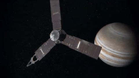
Let Us See Jupiter Through Your Eyes

Our Juno spacecraft will fly over Jupiter’s Great Red Spot on July 10 at 10:06 p.m. EDT. This will be humanity’s first up-close and personal view of the gas giant’s iconic 10,000-mile-wide storm, which has been monitored since 1830 and possibly existing for more than 350 years.

The data collection of the Great Red Spot is part of Juno’s sixth science flyby over Jupiter’s mysterious cloud tops. Perijove (the point at which an orbit comes closest to Jupiter’s center) will be July 10 at 9:55 p.m. EDT.

At the time of perijove, Juno will be about 2,200 miles above the planet’s cloud tops. Eleven minutes and 33 seconds later…Juno will have covered another 24,713 miles and will be directly above the coiling crimson cloud tops of the Great Red Spot. The spacecraft will pass about 5,600 miles above its clouds.
When will we see images from this flyby?
During the flyby, all eight of the spacecraft’s instruments will be turned on, as well as its imager, JunoCam. Because the spacecraft will be collecting data with its Microwave Radiometer (MWR), which measures radio waves from Jupiter’s deep atmosphere, we cannot downlink information during the pass. The MWR can tell us how much water there is and how material is moving far below the cloud tops.
During the pass, all data will be stored on-board…with a downlink planned afterwards. Once the downlink begins, engineering data from the spacecraft’s instruments will come to Earth first, followed by images from JunoCam.
The unprocessed, raw images will be located HERE, on approximately July 14. Follow @NASAJuno on Twitter for updates.
Did you know you can download and process these raw images?
We invite the public to act as a virtual imaging team…participating in key steps of the process, from identifying features of interest to sharing the finished images online. After JunoCam data arrives on Earth, members of the public can process the images to create color pictures. The public also helps determine which points on the planet will be photographed. Learn more about voting on JunoCam’s next target HERE.

JunoCam has four filters: red, green, blue and near-infrared. We get red, green and blue strips on one spacecraft rotation (the spacecraft rotation rate is 2 revolutions per minute) and the near-infrared strips on the second rotation. To get the final image product, the strips must be stitched together and the colors lined up.
Anything from cropping to color enhancing to collaging is fair game. Be creative!
Submit your images to Juno_outreach@jpl.nasa.gov to be featured on the Mission Juno website!
Check out some of these citizen-scientist processed images from previous Juno orbits:

Credit: Sean Doran (More)

Credit: Amelia Carolina (More)

Credit: Michael Ranger (More)

Credit: Jason Major (More)
Make sure to follow us on Tumblr for your regular dose of space: http://nasa.tumblr.com
All-Star Moments in Space Communications and Navigation
How do we get information from missions exploring the cosmos back to humans on Earth? Our space communications and navigation networks – the Near Space Network and the Deep Space Network – bring back science and exploration data daily.
Here are a few of our favorite moments from 2024.

1. Hip-Hop to Deep Space
The stars above and on Earth aligned as lyrics from the song “The Rain (Supa Dupa Fly)” by hip-hop artist Missy Elliott were beamed to Venus via NASA’s Deep Space Network. Using a 34-meter (112-foot) wide Deep Space Station 13 (DSS-13) radio dish antenna, located at the network’s Goldstone Deep Space Communications Complex in California, the song was sent at 10:05 a.m. PDT on Friday, July 12 and traveled about 158 million miles from Earth to Venus — the artist’s favorite planet. Coincidentally, the DSS-13 that sent the transmission is also nicknamed Venus!

NASA's PACE mission transmitting data to Earth through NASA's Near Space Network.
2. Lemme Upgrade You
Our Near Space Network, which supports communications for space-based missions within 1.2 million miles of Earth, is constantly enhancing its capabilities to support science and exploration missions. Last year, the network implemented DTN (Delay/Disruption Tolerant Networking), which provides robust protection of data traveling from extreme distances. NASA’s PACE (Plankton, Aerosol, Cloud, ocean Ecosystem) mission is the first operational science mission to leverage the network’s DTN capabilities. Since PACE’s launch, over 17 million bundles of data have been transmitted by the satellite and received by the network’s ground station.

A collage of the pet photos sent over laser links from Earth to LCRD and finally to ILLUMA-T (Integrated LCRD Low Earth Orbit User Modem and Amplifier Terminal) on the International Space Station. Animals submitted include cats, dogs, birds, chickens, cows, snakes, and pigs.
3. Who Doesn’t Love Pets?
Last year, we transmitted hundreds of pet photos and videos to the International Space Station, showcasing how laser communications can send more data at once than traditional methods. Imagery of cherished pets gathered from NASA astronauts and agency employees flowed from the mission ops center to the optical ground stations and then to the in-space Laser Communications Relay Demonstration (LCRD), which relayed the signal to a payload on the space station. This activity demonstrated how laser communications and high-rate DTN can benefit human spaceflight missions.

4K video footage was routed from the PC-12 aircraft to an optical ground station in Cleveland. From there, it was sent over an Earth-based network to NASA’s White Sands Test Facility in Las Cruces, New Mexico. The signals were then sent to NASA’s Laser Communications Relay Demonstration spacecraft and relayed to the ILLUMA-T payload on the International Space Station.
4. Now Streaming
A team of engineers transmitted 4K video footage from an aircraft to the International Space Station and back using laser communication signals. Historically, we have relied on radio waves to send information to and from space. Laser communications use infrared light to transmit 10 to 100 times more data than radio frequency systems. The flight tests were part of an agency initiative to stream high-bandwidth video and other data from deep space, enabling future human missions beyond low-Earth orbit.

The Near Space Network provides missions within 1.2 million miles of Earth with communications and navigation services.
5. New Year, New Relationships
At the very end of 2024, the Near Space Network announced multiple contract awards to enhance the network’s services portfolio. The network, which uses a blend of government and commercial assets to get data to and from spacecraft, will be able to support more missions observing our Earth and exploring the cosmos. These commercial assets, alongside the existing network, will also play a critical role in our Artemis campaign, which calls for long-term exploration of the Moon.

On Monday, Oct. 14, 2024, at 12:06 p.m. EDT, a SpaceX Falcon Heavy rocket carrying NASA’s Europa Clipper spacecraft lifts off from Launch Complex 39A at NASA’s Kennedy Space Center in Florida.
6. 3, 2, 1, Blast Off!
Together, the Near Space Network and the Deep Space Network supported the launch of Europa Clipper. The Near Space Network provided communications and navigation services to SpaceX’s Falcon Heavy rocket, which launched this Jupiter-bound mission into space! After vehicle separation, the Deep Space Network acquired Europa Clipper’s signal and began full mission support. This is another example of how these networks work together seamlessly to ensure critical mission success.

Engineer Adam Gannon works on the development of Cognitive Engine-1 in the Cognitive Communications Lab at NASA’s Glenn Research Center.
7. Make Way for Next-Gen Tech
Our Technology Education Satellite program organizes collaborative missions that pair university students with researchers to evaluate how new technologies work on small satellites, also known as CubeSats. In 2024, cognitive communications technology, designed to enable autonomous space communications systems, was successfully tested in space on the Technology Educational Satellite 11 mission. Autonomous systems use technology reactive to their environment to implement updates during a spaceflight mission without needing human interaction post-launch.

A first: All six radio frequency antennas at the Madrid Deep Space Communication Complex, part of NASA’s Deep Space Network (DSN), carried out a test to receive data from the agency’s Voyager 1 spacecraft at the same time.
8. Six Are Better Than One
On April 20, 2024, all six radio frequency antennas at the Madrid Deep Space Communication Complex, part of our Deep Space Network, carried out a test to receive data from the agency’s Voyager 1 spacecraft at the same time. Combining the antennas’ receiving power, or arraying, lets the network collect the very faint signals from faraway spacecraft.
Here’s to another year connecting Earth and space.
Make sure to follow us on Tumblr for your regular dose of space!
What is so special about the solar eclipse to you??
Huh, that’s a very good question and I probably answer it differently each time I get asked it. I love the fact that in totality you can see the solar atmosphere and get a chance to see the magnetic field structure of the Sun. This is something that you can’t normally do. I also love the idea that we’re going to be able to test a bunch of ionospheric models with the help of citizen scientist! This again is a very unique opportunity! But probably the thing that seems so special about this particular eclipse is seeing how excited everyone is about it! Most days I sit in my office working on my science (which I think is the best science and most interesting thing in the world- but I’m probably biased about that) and not too many other people in the world are all that excited about it. But with the eclipse, I get to share how cool this science is, and it’s amazing to see everyone get involved!
How Airglow Can Help Us Understand the Sun’s Influence on Earth
You may have seen the famous blue marble or pale blue dot images showing Earth from 18,000 and 3.7 billion miles away, respectively. But closer to home — some 300 miles above Earth's surface — you might encounter an unfamiliar sight: vibrant swaths of red and green or purple and yellow light emanating from the upper atmosphere.
This light is airglow.

Airglow is created when atoms and molecules in the upper atmosphere, excited by sunlight, emit light to shed excess energy. Or, it can happen when atoms and molecules that have been ionized by sunlight collide with and capture a free electron. In both cases, these atmospheric particles emit light in order to relax again. The process is similar to how auroras are created, but while auroras are driven by high-energy solar wind, airglow is energized by day-to-day solar radiation.

Since sunlight is constant, airglow constantly shines throughout Earth’s atmosphere, and the result is a tenuous bubble of light that closely encases our planet. Its light is too dim to see easily except in orbit or on the ground with clear, dark skies and a sensitive camera — it’s one-tenth as bright as the light given off by all the stars in the night sky.

Airglow highlights a key part of our atmosphere: the ionosphere. Stretching from roughly 50 to 400 miles above Earth’s surface, the ionosphere is an electrified layer of the upper atmosphere generated by extreme ultraviolet radiation from the Sun. It reacts to both terrestrial weather below and solar energy streaming in from above, forming a complex space weather system. Turbulence in this ever-changing sea of charged particles can manifest as disruptions that interfere with Earth-orbiting satellites or communication and navigation signals.

Understanding the ionosphere’s extreme variability is tricky because it requires untangling interactions between the different factors at play — interactions of which we don’t have a clear picture. That’s where airglow comes in. Each atmospheric gas has its own favored airglow color, hangs out at a different height and creates airglow by a different process, so we can use airglow to study different layers of the atmosphere.

Airglow carries information on the upper atmosphere’s temperature, density, and composition, but it also helps us trace how particles move through the region itself. Vast, high-altitude winds sweep through the ionosphere, pushing its contents around the globe — and airglow’s subtle dance follows their lead, highlighting global patterns.

Two NASA missions take advantage of precisely this effect to study the upper atmosphere: ICON — short for Ionospheric Connection Explorer — and GOLD — Global-scale Observations of the Limb and Disk.
ICON focuses on how charged and neutral gases in the upper atmosphere behave and interact, while GOLD observes what drives change — the Sun, Earth’s magnetic field or the lower atmosphere — in the region.

By imaging airglow, the two missions will enable scientists to tease out how space and Earth’s weather intersect, dictating the region’s complex behavior.
Keep up with the latest in NASA's airglow and upper atmosphere research on Twitter and Facebook or at nasa.gov/sunearth.
Make sure to follow us on Tumblr for your regular dose of space: http://nasa.tumblr.com.
-
 raytoroinmybackpack liked this · 9 months ago
 -
 arbreligno liked this · 2 years ago
 -
 letuce369 reblogged this · 2 years ago
 -
 ava1enzue1a reblogged this · 2 years ago
 -
ava1enzue1a liked this · 2 years ago
-
 femmeviva reblogged this · 2 years ago
 -
 crowned-pigeon liked this · 2 years ago
 -
 juteanworld liked this · 2 years ago
 -
 ilovesnakes88 liked this · 3 years ago
 -
 kj1900 reblogged this · 3 years ago
 -
kj1900 liked this · 3 years ago
-
 mygotholdladyheart reblogged this · 3 years ago
 -
mygotholdladyheart liked this · 3 years ago
-
 polybiuspaws liked this · 3 years ago
 -
 bernie-coldmax reblogged this · 3 years ago
 -
bernie-coldmax liked this · 3 years ago
-
 mataashitamyhashi reblogged this · 3 years ago
 -
 palenge liked this · 3 years ago
 -
 the-void-in-general liked this · 3 years ago
 -
 appla1 reblogged this · 3 years ago
 -
 our1planet2112 reblogged this · 3 years ago
 -
 briaboy liked this · 3 years ago
 -
 notsospoon liked this · 3 years ago
 -
 lekaisernoir liked this · 3 years ago
 -
 world-of-nothanks liked this · 3 years ago
 -
 fibrofuck reblogged this · 3 years ago
 -
 aristi-world liked this · 3 years ago
 -
 somni-omni liked this · 3 years ago
 -
 yhlaura liked this · 3 years ago
 -
 iamdaisyy liked this · 3 years ago
 -
 enby-astronaut liked this · 3 years ago
 -
 sexuall-ramm reblogged this · 3 years ago
 -
sexuall-ramm liked this · 3 years ago
-
 a-rainbow-seeker reblogged this · 3 years ago
 -
 den1990 reblogged this · 3 years ago
 -
 judeofberkeley liked this · 3 years ago
Explore the universe and discover our home planet with the official NASA Tumblr account
1K posts