The NASA “Worm” Logo
The NASA “Worm” Logo
Just like many organizations, the style and logos can change over time. You are probably most familiar with our “meatball” logo. No, unfortunately this does not refer to the delicious food. This logo (below) is our most popular symbol, and dates back to 1959.

But, we’ve also had other insignia that represented our organization throughout the years.
The “worm” logo (below) was used by the agency from 1975 until 1992. The organization wanted to create a more “modern” logo, which resulted in the unique type style of the “worm” logo.

Even though this logo was retired in 1992, the Graphics Standards Manual is still available online HERE.
You can also read up about the emblems, logos and insignia used by NASA throughout the years in a new e-Book available for free HERE.
Make sure to follow us on Tumblr for your regular dose of space:http://nasa.tumblr.com
More Posts from Nasa and Others
NASA Science Show & Tell
This week, we’re at one of the biggest science conferences in the country, where our scientists are presenting new results from our missions and projects. It’s called the American Geophysical Union’s Fall Meeting.
Here are a few of the things we shared this week...

The Sun
A few months into its seven-year mission, Parker Solar Probe has already flown far closer to the Sun than any spacecraft has ever gone. The data from this visit to the Sun has just started to come back to Earth, and scientists are hard at work on their analysis.

Parker Solar Probe sent us this new view of the Sun’s outer atmosphere, the corona. The image was taken by the mission’s WISPR instrument on Nov. 8, 2018, and shows a coronal streamer seen over the east limb of the Sun. Coronal streamers are structures of solar material within the Sun's atmosphere, the corona, that usually overlie regions of increased solar activity. The fine structure of the streamer is very clear, with at least two rays visible. Parker Solar Probe was about 16.9 million miles from the Sun's surface when this image was taken. The bright object near the center of the image is Mercury, and the dark spots are a result of background correction.
Hurricane Maria
Using a satellite view of human lights, our scientists watched the lights go out in Puerto Rico after Hurricane Maria. They could see the slow return of electricity to the island, and track how rural and mountainous regions took longer to regain power.

In the spring, a team of scientists flew a plane over Puerto Rico’s forests, using a laser instrument to measure how trees were damaged and how the overall structure of the forests had changed.

Earth’s Ice
Our scientists who study Antarctica saw some surprising changes to East Antarctica. Until now, most of the continent’s melting has been on the peninsula and West Antarctica, but our scientists have seen glaciers in East Antarctica lose lots of ice in the last few years.


Our ICESat-2 team showed some of their brand new data. From the changing height of Antarctic ice to lagoons off the coast of Mexico, the little satellite has spent its first few months measuring our planet in 3D. The laser pulses even see individual ocean waves, in this graph.

Scientists are using our satellite data to track Adélie penguin populations, by using an unusual proxy -- pictures of their poop! Penguins are too small to be seen by satellites, but they can see large amounts of their poop (which is pink!) and use that as a proxy for penguin populations.

Asteroid Bennu
Our OSIRIS-REx mission recently arrived at its destination, asteroid Bennu. On approach, data from the spacecraft’s spectrometers revealed chemical signatures of water trapped in clay minerals. While Bennu itself is too small to have ever hosted liquid water, the finding indicates that liquid water was present at some time on Bennu’s parent body, a much larger asteroid.
We also released a new, detailed shape model of Bennu, which is very similar to our ground-based observations of Bennu’s shape. This is a boon to ground-based radar astronomy since this is our first validation of the accuracy of the method for an asteroid! One change from the original shape model is the size of the large boulder near Bennu’s south pole, nicknamed “Benben.” The boulder is much bigger than we thought and overall, the quantity of boulders on the surface is higher than expected. Now the team will make further observations at closer ranges to more accurately assess where a sample can be taken on Bennu to later be returned to Earth.

Jupiter
The Juno mission celebrated it’s 16th science pass of #Jupiter, marking the halfway point in data collection of the prime mission. Over the second half of the prime mission — science flybys 17 through 32 — the spacecraft will split the difference, flying exactly halfway between each previous orbit. This will provide coverage of the planet every 11.25 degrees of longitude, providing a more detailed picture of what makes the whole of Jupiter tick.

Mars
The Mars 2020 team had a workshop to discuss the newly announced landing site for our next rover on the Red Planet. The landing site...Jezero Crater! The goal of Mars 2020 is to learn whether life ever existed on Mars. It's too cold and dry for life to exist on the Martian surface today. But after Jezero Crater formed billions of years ago, water filled it to form a deep lake about the same size as Lake Tahoe. Eventually, as Mars' climate changed, Lake Jezero dried up. And surface water disappeared from the planet.
Interstellar Space
Humanity now has two interstellar ambassadors. On Nov. 5, 2018, our Voyager 2 spacecraft left the heliosphere — the bubble of the Sun’s magnetic influence formed by the solar wind. It’s only the second-ever human-made object to enter interstellar space, following its twin, Voyager 1, that left the heliosphere in 2012.

Scientists are especially excited to keep receiving data from Voyager 2, because — unlike Voyager 1 — its plasma science instrument is still working. That means we’ll learn brand-new information about what fills the space between the stars.
Learn more about NASA Science at science.nasa.gov.
Make sure to follow us on Tumblr for your regular dose of space: http://nasa.tumblr.com
Taking Solar Science to New Heights
We're on the verge of launching a new spacecraft to the Sun to take the first-ever images of the Sun's north and south poles!

Credit: ESA/ATG medialab
Solar Orbiter is a collaboration between the European Space Agency (ESA) and NASA. After it launches — as soon as Feb. 9 — it will use Earth's and Venus's gravity to swing itself out of the ecliptic plane — the swath of space, roughly aligned with the Sun’s equator, where all the planets orbit. From there, Solar Orbiter's bird’s eye view will give it the first-ever look at the Sun's poles.

Credit: ESA/ATG medialab
The Sun plays a central role in shaping space around us. Its massive magnetic field stretches far beyond Pluto, paving a superhighway for charged solar particles known as the solar wind. When bursts of solar wind hit Earth, they can spark space weather storms that interfere with our GPS and communications satellites — at their worst, they can even threaten astronauts.
To prepare for potential solar storms, scientists monitor the Sun’s magnetic field. But from our perspective near Earth and from other satellites roughly aligned with Earth's orbit, we can only see a sidelong view of the Sun's poles. It’s a bit like trying to study Mount Everest’s summit from the base of the mountain.

Solar Orbiter will study the Sun's magnetic field at the poles using a combination of in situ instruments — which study the environment right around the spacecraft — and cameras that look at the Sun, its atmosphere and outflowing material in different types of light. Scientists hope this new view will help us understand not only the Sun's day-to-day activity, but also its roughly 11-year activity cycles, thought to be tied to large-scales changes in the Sun's magnetic field.
Solar Orbiter will fly within the orbit of Mercury — closer to our star than any Sun-facing cameras have ever gone — so the spacecraft relies on cutting-edge technology to beat the heat.

Credit: ESA/ATG medialab
Solar Orbiter has a custom-designed titanium heat shield with a calcium phosphate coating that withstands temperatures more than 900 degrees Fahrenheit — 13 times the solar heating that spacecraft face in Earth orbit. Five of the cameras look at the Sun through peepholes in that heat shield; one observes the solar wind out the side.
Over the mission’s seven-year lifetime, Solar Orbiter will reach an inclination of 24 degrees above the Sun’s equator, increasing to 33 degrees with an additional three years of extended mission operations. At closest approach the spacecraft will pass within 26 million miles of the Sun.
Solar Orbiter will be our second major mission to the inner solar system in recent years, following on August 2018’s launch of Parker Solar Probe. Parker has completed four close solar passes and will fly within 4 million miles of the Sun at closest approach.

Solar Orbiter (green) and Parker Solar Probe (blue) will study the Sun in tandem.
The two spacecraft will work together: As Parker samples solar particles up close, Solar Orbiter will capture imagery from farther away, contextualizing the observations. The two spacecraft will also occasionally align to measure the same magnetic field lines or streams of solar wind at different times.
Watch the launch

The booster of a United Launch Alliance Atlas V rocket that will launch the Solar Orbiter spacecraft is lifted into the vertical position at the Vertical Integration Facility near Space Launch Complex 41 at Cape Canaveral Air Force Station in Florida on Jan. 6, 2020. Credit: NASA/Ben Smegelsky
Solar Orbiter is scheduled to launch on Feb. 9, 2020, during a two-hour window that opens at 11:03 p.m. EST. The spacecraft will launch on a United Launch Alliance Atlas V 411 rocket from Space Launch Complex 41 at Cape Canaveral Air Force Station in Florida.
Launch coverage begins at 10:30 p.m. EST on Feb. 9 at nasa.gov/live. Stay up to date with mission at nasa.gov/solarorbiter!
Make sure to follow us on Tumblr for your regular dose of space: http://nasa.tumblr.com
Perfect 10: A Decade of Studying Ice from the Sky
From 2009 through 2019, our Operation IceBridge flew planes above the Arctic, Antarctic and Alaska, measuring the height, depth, thickness, flow and change of sea ice, glaciers and ice sheets.

IceBridge was designed to “bridge” the years between NASA’s two Ice, Cloud, and land Elevation Satellites, ICESat and ICESat-2. IceBridge made its final polar flight in November 2019, one year after ICESat-2’s successful launch.
A lot of amazing science happens in a decade of fundamentally changing the way we see ice. Here, in chronological order, are 10 of IceBridge’s most significant and exciting achievements.
2009: Go for launch

The first ICESat monitored ice, clouds, atmospheric particles and vegetation globally beginning in 2003. As ICESat neared the end of its life, we made plans to keep measuring ice elevation with aircraft until ICESat-2’s launch.
ICESat finished its service in August 2009, leaving IceBridge in charge of polar ice tracking for the next decade.
2009: Snow on sea ice

To measure how thick sea ice is, we first have to know how much snow is accumulated on top of the ice. Using a snow radar instrument, IceBridge gathered the first widespread data set of snow thickness on top of both Arctic and Antarctic sea ice.
2009: Getting to the bottom of glaciers

IceBridge mapped hundreds of miles of grounding lines in both Antarctica and Greenland. Grounding lines are where a glacier’s bottom loses contact with the bedrock and begins floating on seawater – a grounding line that is higher than rock that the ice behind it is resting on increases the possibility of glaciers retreating in the future.
The team mapped 200 glaciers along Greenland’s coastal areas, as well as coastal areas, the interior of the Greenland Ice Sheet and high-priority areas in Antarctica.
2011: Spotting cracks in the ice

While flying Antarctica in 2011, IceBridge scientists spotted a massive crack in Pine Island Glacier, one of the fastest-changing glaciers on the continent. The crack produced a new iceberg that October.
Pine Island has grown thinner and more unstable in recent decades, spawning new icebergs almost every year. IceBridge watched for cracks that could lead to icebergs and mapped features like the deep water channel underneath Pine Island Glacier, which may bring warm water to its underside and make it melt faster.
2013: Making a map of rock

Using surface elevation, ice thickness and bedrock topography data from ICESat, IceBridge and international partners, the British Antarctic Survey created an updated map of the bedrock beneath Antarctic ice.
Taking gravity and magnetic measurements helps scientists understand what kind of rock lies below the ice sheet. Soft rock and meltwater make ice flow faster, while hard rock makes it harder for the ice to flow quickly.
2013: Surprises under the ice

IceBridge’s airborne radar data helped map the bedrock underneath the Greenland Ice Sheet, revealing a previously unknown canyon more than 400 miles long and up to a half mile deep slicing through the northern half of the country.
The “grand canyon” of Greenland may have once been a river system, and today likely transports meltwater from Greenland’s interior to the Arctic Ocean.
2015: It’s what’s inside (the ice sheet) that counts

After mapping the bedrock under the Greenland Ice Sheet, scientists turned their attention to the middle layers of the ice. Using both ice-penetrating radar and ice samples taken in the field, IceBridge created the first map of the ice sheet’s many layers, formed as thousands of years of snow became compacted downward and formed ice.
Making the 3D map of Greenland’s ice layers gave us clues as to how the ice sheet has warmed in the past, and where it may be frozen to bedrock or slowly melting instead.
2018: Gap bridged!

ICESat-2 launched on September 15, 2018, rocketing IceBridge into the final phase of its mission: Connecting ICESat and ICESat-2.
IceBridge continued flying after ICESat-2’s launch, working to verify the new satellite’s measurements. By conducting precise underflights, where planes traced the satellite’s orbit lines and took the same measurements at nearly the same time, the science teams could compare results and make sure ICESat-2’s instruments were functioning properly.
2018: An impact crater under the ice

Using IceBridge data, an international team of scientists found an impact crater from a meteor thousands of years in the past. The crater is larger than the city of Washington, D.C., likely created by a meteor more than half a mile wide.
2019: Flying into the sunset

In 2019, IceBridge continued flying in support of ICESat-2 for its Arctic and Antarctic campaigns. The hundreds of terabytes of data the team collected over the decade will fuel science for years to come.
IceBridge finished its last polar flight on November 20, 2019. The team will complete one more set of Alaska flights in 2020.
Make sure to follow us on Tumblr for your regular dose of space: http://nasa.tumblr.com
That’s a wrap folks! Gucci is signing off. Thank you for all the amazing questions. Didn’t get your question answered? No worries! We’re coming to you live next week in our second Answer Time of 2020, featuring NASA Astronaut Nick Hague. Submit your questions now here: https://nasa.tumblr.com/ask

What extra-curricular activities do you suggest to make the most of our time in high school for a job in NASA?
There are so many great things to get into. I regret that I worked mostly in high school and didn’t spend more time in extracurricular activities. If I could go back, I would be more active in sports because that helps with learning about teamwork and keeps you fit. Lastly, I would get involved on an academic team to keep your brain fit.
What Are the Bright Spots on Ceres?

Dwarf planet Ceres has more than 130 bright areas, and most of them are associated with impact craters. Now, Ceres has revealed some of its well-kept secrets in two new studies in the journal Nature, thanks to data from our Dawn spacecraft.
Two studies have been looking into the mystery behind these bright areas. One study identifies this bright material as a kind of salt, while the other study suggests the detection of ammonia-rich clays.
Study authors write that the bright material is consistent with a type of magnesium sulfate called hexahydrite. A different type of magnesium sulfate is familiar on Earth as Epsom salt.

Researchers, using images from Dawn’s framing camera, suggest that these salt-rich areas were left behind when water-ice sublimated in the past. Impacts from asteroids would have unearthed the mixture of ice and salt.
An image of Occator Crater (below) shows the brightest material on Ceres. Occator itself is 60 miles in diameter, and its central pit, covered by this bright material, measures about 6 miles wide. With its sharp rim and walls, it appears to be among the youngest features on the dwarf planet.

In the second nature study, members of the Dawn science team examined the composition of Ceres and found evidence for ammonia-rich clays. Why is this important?
Well, ammonia ice by itself would evaporate on Ceres today, because it is too warm. However, ammonia molecules could be stable if present in combination with other minerals. This raises the possibility that Ceres did not originate in the main asteroid belt between Mars and Jupiter, where it currently resides. But instead, might have formed in the outer solar system! Another idea is that Ceres formed close to its present position, incorporating materials that drifted in from the outer solar system, near the orbit of Neptune, where nitrogen ices are thermally stable.

As of this week, our Dawn spacecraft has reached its final orbital altitude at Ceres (about 240 miles from the surface). In mid-December, it will begin taking observations from this orbit, so be sure to check back for details!
ake sure to follow us on Tumblr for your regular dose of space: http://nasa.tumblr.com
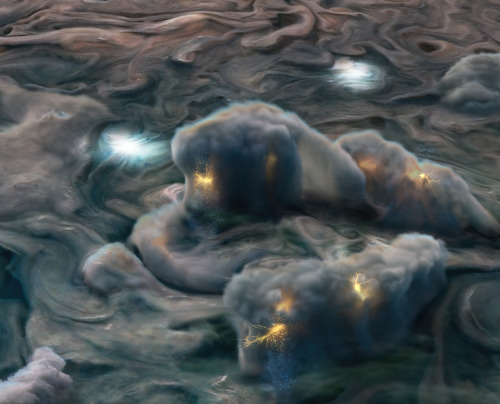
New results from our Juno mission suggest the planet is home to “shallow lightning.” An unexpected form of electrical discharge, shallow lightning comes from a unique ammonia-water solution.
It was previously thought that lightning on Jupiter was similar to Earth, forming only in thunderstorms where water exists in all its phases – ice, liquid, and gas. But flashes observed at altitudes too cold for pure liquid water to exist told a different story. This illustration uses data obtained by the mission to show what these high-altitude electrical storms look like.
Understanding the inner workings of Jupiter allows us to develop theories about atmospheres on other planets and exoplanets!
Illustration Credit: NASA/JPL-Caltech/SwRI/MSSS/Gerald Eichstädt/Heidi N. Becker/Koji Kuramura
Make sure to follow us on Tumblr for your regular dose of space: http://nasa.tumblr.com
Solar System: Things to Know This Week
Not to be—ahem—eclipsed, the Perseids meteor shower peaks annually in mid-August and is considered the most popular meteor shower of the year.
This week, 10 things you need to know about this beautiful nighttime show and how to catch a front-row seat.
1. Light in August

In this 30 second exposure, a meteor streaks across the sky during the annual Perseid meteor shower Friday, Aug. 12, 2016 in Spruce Knob, West Virginia. The Perseids show up every year in August when Earth ventures through trails of debris left behind by an ancient comet. Image Credit: NASA/Bill Ingalls
With very fast and bright meteors, Perseids (pronounced PURR-see-ids) frequently leave long "wakes" of light and color behind them as they streak through Earth's atmosphere. Perseids are one of the most plentiful showers, with between 50-100 meteors seen each hour, and occur with warm summer nighttime weather, allowing sky watchers to easily view them.
2. Show Schedule
You can see the Perseids this year between now and Aug. 24, 2017, but mark your calendars for peak dates Aug. 12 and 13. This year, the waning gibbous moon rises about midnight local time, which will cut the expected rates in half this year (25 to 50 per hour at the peak from a very dark sky). But the Perseids are so bright and numerous that it should still be a good show.
3. Night Owls Welcome
The Perseids (and every meteor shower) are best viewed in the Northern Hemisphere between 11 p.m. - 3 a.m. Come prepared with a sleeping bag, blanket or lawn chair.
4. Look Up

Find an area well away from city or street lights and set up where you're shadowed from the moon's glare. Face whatever direction you like, ideally the one unobstructed by trees, buildings or moonlight. Look up, taking in as much of the sky as possible. If you have a group, each person should look in different parts of the sky. After about 30 minutes in the dark, your eyes will adapt, and you'll begin to see fainter objects, including meteors. Be patient; the show will last until dawn, so you have plenty of time to catch a glimpse.
5. Functional Fashion
Pack a baseball cap and wear it sideways to cover any glare from the moon. The waning gibbous moon will block out many of the fainter meteors this year, but the Perseids are so bright and numerous that it should still be a good show.
6. Meteor Matters
Where do meteors come from? Some originate from leftover comet particles and bits of broken asteroids. When comets come around the sun, they leave a dusty trail behind them. Every year, Earth passes through these debris trails, which allows the bits to collide with our atmosphere and disintegrate to create fiery and colorful streaks in the sky. But the vast majority of meteors don't come from meteor showers—instead, they randomly fall all of the time.
7. Origins

The pieces of space debris that interact with our atmosphere to create the Perseids originate from Comet 109P/Swift-Tuttle. Swift-Tuttle takes 133 years to orbit the sun once, and Comet Swift-Tuttle last visited the inner solar system in 1992. Swift-Tuttle is a large comet: its nucleus is 16 miles (26 kilometers) across. This is almost twice the size of the object hypothesized to have wiped out the dinosaurs.
8. Discoverers
Comet Swift-Tuttle was discovered in 1862 by Lewis Swift and Horace Tuttle. In 1865, Giovanni Schiaparelli realized that this comet was the source of the Perseids.
9. Great Balls of Fire

The Perseids are known for fireballs, which are large explosions of light and color that last longer than an average meteor streak. Why? They originate from bigger particles of cometary material.
10. Sky Map
The point in the sky from which the Perseids appear to come from—also known as their radiant—is the constellation Perseus. But don't get confused: The constellation name only helps viewers figure out which shower they're viewing on a given night; it's not the source of the meteors (see #6 for that answer!).
Make sure to follow us on Tumblr for your regular dose of space: http://nasa.tumblr.com
Space Station Research: Nutrition

Each month, we highlight a different research topic on the International Space Station. In January, our focus is Nutrition. Understanding the role of nutrition in astronaut adaptation to spaceflight has a broader application on Earth. For example, understanding the relationship of nutrition to bone loss in space is potentially valuable for patients suffering from bone loss on Earth.

The space station is being utilized to study the risks to human health that are inherent in space exploration. The human body changes in various ways in microgravity, and nutrition-related investigations help us understand and reduce those risks associated with those changes. Examples are:
Bone mineral density loss
Muscle atrophy
Cardiovascular deconditioning
Immune dysfunction
Radiation
and more
Scientists can also test the effectiveness of potential countermeasures like exercise and nutrition, which can have health benefits for those of us on Earth.

Did you know that in 2015 the space station crew harvested and ate lettuce that was grown on the space station? The Veggie facility on station is an experiment that supports a variety of plant species that can be cultivated for educational outreach, fresh food and even recreation for crew members on long-duration missions. Right now, the crew is growing Zinnia flowers. Understanding how flowering plans grow in microgravity can be applied to growing other edible flowering plants, such as tomatoes.
Make sure to follow us on Tumblr for your regular dose of space: http://nasa.tumblr.com
GPS: Coming to a Moon Near You!

The next generation of lunar explorers – the Artemis generation – will establish a sustained presence on the Moon, making revolutionary discoveries, prospecting for resources and proving technologies key to future deep space exploration. To support these ambitions, our navigation engineers are developing an architecture that will provide accurate, robust location services all the way out to lunar orbit.
How? We’re teaming up with the U.S. Air Force to extend the use of GPS in space by developing advanced space receivers capable of tracking weak GPS signals far out in space.

Spacecraft near Earth have long relied on GPS signals for navigation data, just as users on the ground might use their phones to maneuver through a highway system. Below approximately 1,860 miles, spacecraft in low-Earth orbit can rely on GPS for near-instantaneous location data. This is an enormous benefit to these missions, allowing many satellites the autonomy to react and respond to unforeseen events without much hands-on oversight.

Beyond this altitude, navigation becomes more challenging. To reliably calculate their position, spacecraft must use signals from the global navigation satellite system (GNSS), the collection of international GPS-like satellite constellations. The region of space that can be serviced by these satellites is called the Space Service Volume, which extends from 1,860 miles to about 22,000 miles, or geosynchronous orbit.

In this area of service, missions don’t rely on GNSS signals in the same way one would on Earth or in low-Earth orbit. They orbit too high to “see” enough signals from GNSS satellites on their side of the globe, so they must rely on signals from GNSS satellite signals spilling over to the opposite side of the globe. This is because the Earth blocks the main signals of these satellites, so the spacecraft must “listen” for the fainter signals that extend out from the sides of their antennas, known as “side-lobes.”

Though 22,000 miles is considered the end of the Space Service Volume, that hasn’t stopped our engineers from reaching higher. In fact, our simulations prove that GNSS signals could even be used for reliable navigation in lunar orbit, far outside the Space Service Volume, over 200,000 miles from Earth. We’re even planning to use GNSS signals in the navigation architecture for the Gateway, an outpost in orbit around the Moon that will enable sustained lunar surface exploration.

It’s amazing that the same systems you might use to navigate the highways are putting us on the path forward to the Moon!
Make sure to follow us on Tumblr for your regular dose of space: http://nasa.tumblr.com.
-
 sweetbutterbliss liked this · 1 year ago
 -
 garuda606 liked this · 1 year ago
 -
 sewingtea liked this · 6 years ago
 -
 punk-void reblogged this · 6 years ago
 -
 no-moon-at-all liked this · 6 years ago
 -
 crowlamp liked this · 7 years ago
 -
 cynicxllyspeaking liked this · 7 years ago
 -
 pathetickuroo liked this · 7 years ago
 -
 zacktastic liked this · 7 years ago
 -
 morgannn-ashley liked this · 7 years ago
 -
 oliverneishdesign reblogged this · 7 years ago
 -
 volcoff liked this · 7 years ago
 -
 allofthe-lightsoff liked this · 7 years ago
 -
 thekid-1921 liked this · 7 years ago
 -
 universumnow reblogged this · 7 years ago
 -
 itsjustsunn liked this · 8 years ago
 -
 sunflxwerss liked this · 8 years ago
 -
 hemlockvarnish liked this · 8 years ago
 -
 meganwestgate liked this · 8 years ago
 -
 everythng-you-are reblogged this · 8 years ago
 -
 nikita-shu liked this · 8 years ago
 -
everythng-you-are liked this · 8 years ago
-
 nessiedetka-blog liked this · 8 years ago
 -
 sundaymoringdiamonds liked this · 8 years ago
 -
 nes-useche liked this · 8 years ago
 -
 tiranosauriosrex liked this · 8 years ago
 -
 lemonbalmlesbian reblogged this · 8 years ago
 -
writer0-5-blog liked this · 8 years ago
-
 watdofak liked this · 9 years ago
 -
 ew-rainbows liked this · 9 years ago
 -
 she-stole-my-soul reblogged this · 9 years ago
 -
 catlover264-blog liked this · 9 years ago
 -
 abrigaleee-blog liked this · 9 years ago
 -
 midmidwest reblogged this · 9 years ago
 -
 naturalizerr reblogged this · 9 years ago
 -
 mio6166 reblogged this · 9 years ago
 -
mio6166 liked this · 9 years ago
Explore the universe and discover our home planet with the official NASA Tumblr account
1K posts