Beautiful Canda
beautiful canda


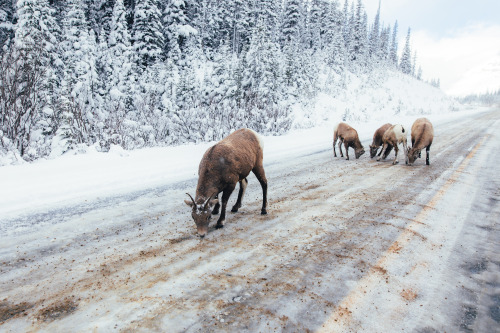

First snow in the Canadian Rockies.
Banff and Jasper National Parks, Alberta, Canada. October 2016.
More Posts from F-taser-blog and Others
The internet of things IOT

6 Reasons NOAA’s GOES-R Satellite Matters

NOAA’s GOES-R weather satellite will soon be launched into space – becoming our nation’s most advanced geostationary satellite to date. So what does that mean for you? Here are six reasons to be excited about GOES-R:
1. GOES-R helps you know what the weather is going to be
Perhaps you turn on the TV or radio, or check your favorite weather website or smartphone weather app to get the latest forecast. No matter the platform of your weather forecast, the data and information for those forecasts come from NOAA’s National Weather Service (NWS).

Weather satellites, like the GOES satellites, are the backbone of NWS forecasts. GOES-R will be more advanced than any other weather satellite of its kind and could make the answer to the question “What’s the weather going to be?” more detailed and accurate both in the near term and further out into the future.
2. GOES-R will get better data faster than ever before
Do you live in an inland state, a state with a coastline or a state with a mountain range? Great, that’s all of you! Data from the GOES-R satellite will be a game changer for forecasters in your area.

Here’s why: satellites are fitted with instruments that observe weather and collect measurements. The primary instrument on the new GOES-R satellite will collect three times more data and provide four times better resolution and more than five times faster coverage than current satellites! This means the satellite can scan Earth’s Western Hemisphere every five minutes and as often as every 30 seconds in areas where severe weather forms, as compared to approximately every 30 minutes with the current GOES satellites. Pretty cool, right?
3. GOES-R is a real life-saver
This expedited data means that forecasts will be timelier, with more “real-time” information in them, allowing NWS to make those warnings and alerts that much faster, thereby potentially saving lives.

And a faster forecast is a big deal for our economy. Commercial shipping and aviation are just two examples of industries that rely on up-to-date weather data for critical decisions about how to route ships and safely divert planes around storms.
4. GOES-R helps keep the electricity flowing
We all depend on a power grid for virtually every aspect of modern life. But power grids are vulnerable to bursts of energy from the sun that can affect us on Earth.

Luckily, GOES-R will be sitting over 22,000 miles above us, and in addition to measuring weather on Earth, it will monitor incoming space weather.
5. GOES-R is truly revolutionary
How different will GOES-R be? Imagine going from your classic black and white TV to a new high definition one. It will enable NOAA to gather data using three times more channels, four times the resolution, five times faster than the current GOES satellites.

This faster, more accurate data means better observations of developing storms and other severe weather.
6. GOES-R will be a continuing a legacy
GOES-R may be the first of its kind, but it is the heir to a rich tradition of geostationary earth observation.

In fact, NOAA has continuously operated a GOES satellite for over 40 years. Since 1975, GOES satellites have taken well over 3 million images!

The GOES-R satellite is scheduled to launch Saturday, Nov. 19 at 5:42 p.m. EST aboard a United Launch Alliance Atlas V rocket. Liftoff will occur from our Kennedy Space Center in Florida.
Learn more about the mission: https://www.nesdis.noaa.gov/GOES-R-Mission
Article Credit: NOAA
Make sure to follow us on Tumblr for your regular dose of space: http://nasa.tumblr.com
Solar System: Things to Know This Week
There’s even more to Mars.

1. Batten Down the Hatches
Good news for future astronauts: scientists are closer to being able to predict when global dust storms will strike the Red Planet. The winds there don’t carry nearly the same force that was shown in the movie “The Martian,” but the dust lofted by storms can still wreak havoc on people and machines, as well as reduce available solar energy. Recent studies indicate a big storm may be brewing during the next few months.
+ Get the full forecast

2. Where No Rover Has Gone Before
Our Opportunity Mars rover will drive down an ancient gully that may have been carved by liquid water. Several spacecraft at Mars have observed such channels from a distance, but this will be the first up-close exploration. Opportunity will also, for the first time, enter the interior of Endeavour Crater, where it has worked for the last five years. All this is part of a two-year extended mission that began Oct. 1, the latest in a series of extensions going back to the end of Opportunity’s prime mission in April 2004. Opportunity landed on Mars in January of that year, on a mission planned to last 90 Martian days (92.4 Earth days). More than 12 Earth years later, it’s still rolling.
+ Follow along + See other recent pictures from Endeavour Crater

3. An Uphill Climb
Opportunity isn’t the only NASA Mars rover getting a mission extension. On the other side of the planet, the Curiosity rover is driving and collecting samples amid some of the most scenic landscapes ever visited on Mars. Curiosity’s two-year mission extension also began Oct. 1. It’s driving toward uphill destinations, including a ridge capped with material rich in the iron-oxide mineral hematite, about a mile-and-a-half (two-and-a-half kilometers) ahead. Beyond that, there’s an exposure of clay-rich bedrock. These are key exploration sites on lower Mount Sharp, which is a layered, Mount-Rainier-size mound where Curiosity is investigating evidence of ancient, water-rich environments that contrast with the harsh, dry conditions on the surface of Mars today.
+ Learn more

4. Keep a Sharp Lookout
Meanwhile, the Mars Reconnaissance Orbiter continues its watch on the Red Planet from above. The mission team has just released a massive new collection of super-high-resolution images of the Martian surface.
+ Take a look

5. 20/20 Vision for the 2020 Rover
In the year 2020, Opportunity and Curiosity will be joined by a new mobile laboratory on Mars. In the past week, we tested new “eyes” for that mission. The Mars 2020 rover’s Lander Vision System helped guide the rocket to a precise landing at a predesignated target. The system can direct the craft toward a safe landing at its primary target site or divert touchdown toward better terrain if there are hazards in the approaching target area.
+ Get details
Discover the full list of 10 things to know about our solar system this week HERE.
Make sure to follow us on Tumblr for your regular dose of space: http://nasa.tumblr.com
Why Do We Study Ice?
Discover why we study ice and how this research benefits Earth.

We fly our DC-8 aircraft very low over Antarctica as part of Operation IceBridge – a mission that’s conducting the largest-ever airborne survey of Earth’s polar ice.

Records show that 2015 was the warmest year on record, and this heat affects the Arctic and Antarctica – areas that serve as a kind of air conditioner for Earth and hold an enormous of water.

IceBridge flies over both Greenland and Antarctica to measure how the ice in these areas is changing, in part because of rising average global temperatures.
IceBridge’s data has shown that most of Antarctica’s ice loss is occurring in the western region. All that melting ice flows into the ocean, contributing to sea level rise.

IceBridge has been flying the same routes since the mission began in 2009. Data from the flights help scientists better measure year-to-year changes.

IceBridge carries the most sophisticated snow and ice instruments ever flown. Its main instrument is called the Airborne Topographic Mapper, or ATM.The ATM laser measure changes in the height of the ice surface by measuring the time it takes for laser light to bounce off the ice and return to the plane – ultimately mapping ice in great detail, like in this image of Antarctica’s Crane Glacier.

For the sake of the laser, IceBridge planes have to fly very low over the surface of snow and ice, sometimes as low as 1,000 feet above the ground. For comparison, commercial flights usually stay around 30,000 feet! Two pilots and a flight enginner manage the many details involved in each 10- to 12-hour flight.

One of the scientific radars that fly aboard IceBridge helped the British Antarctic Survey create this view of what Antarctica would look like without any ice.

IceBridge also studies gravity using a very sensitive instrument that can measure minuscule gravitational changes, allowing scientists to map the ocean cavities underneath the ice edges of Antarctica. This data is essential for understanding how the ice and the ocean interact. The instrument’s detectors are very sensitive to cold, so we bundle it up to keep it warm!

Though the ice sheet of Antarctica is two miles thick in places, the ice still “flows” – faster in some places and slower in others. IceBridge data helps us track how much glaciers change from year-to-year.

Why do we call this mission IceBridge? It is bridging the gap between our Ice, Cloud and Land Elevation Satellite, or ICESat – which gathered data from 2003 to 2009 – and ICESat-2, which will launch in 2018.

Learn more about our IceBridge mission here: www.nasa.gov/icebridge and about all of our ice missions on Twitter at @NASA_Ice.
Make sure to follow us on Tumblr for your regular dose of space: http://nasa.tumblr.com
Hunting for Organic Molecules on Mars

Did Mars once have life? To help answer that question, an international team of scientists created an incredibly powerful miniature chemistry laboratory, set to ride on the next Mars rover.

The instrument, called the Mars Organic Molecule Analyzer Mass Spectrometer (MOMA-MS), will form a key part of the ExoMars Rover, a joint mission between the European Space Agency (ESA) and Roscosmos. A mass spectrometer is crucial to send to Mars because it reveals the elements that can be found there. A Martian mass spectrometer takes a sample, typically of powdered rock, and distinguishes the different elements in the sample based on their mass.

After 8 years of designing, building, and testing, NASA scientists and engineers from NASA’s Goddard Space Flight Center said goodbye to their tiny chemistry lab and shipped it to Italy in a big pink box. Building a tiny instrument capable of conducting chemical analysis is difficult in any setting, but designing one that has to launch on a huge rocket, fly through the vacuum of space, and then operate on a planet with entirely different pressure and temperature systems? That’s herculean. And once on Mars, MOMA has a very important job to do. NASA Goddard Center Director Chris Scolese said, “This is the first intended life-detecting instrument that we have sent to Mars since Viking.”

The MOMA instrument will be capable of detecting a wide variety of organic molecules. Organic compounds are commonly associated with life, although they can be created by non-biological processes as well. Organic molecules contain carbon and hydrogen, and can include oxygen, nitrogen, and other elements.

To find these molecules on Mars, the MOMA team had to take instruments that would normally occupy a couple of workbenches in a chemistry lab and shrink them down to roughly the size of a toaster oven so they would be practical to install on a rover.

MOMA-MS, the mass spectrometer on the ExoMars rover, will build on the accomplishments from the Sample Analysis at Mars (SAM), an instrument suite on the Curiosity rover that includes a mass spectrometer. SAM collects and analyzes samples from just below the surface of Mars while ExoMars will be the first to explore deep beneath the surface, with a drill capable of taking samples from as deep as two meters (over six feet). This is important because Mars’s thin atmosphere and spotty magnetic field offer little protection from space radiation, which can gradually destroy organic molecules exposed on the surface. However, Martian sediment is an effective shield, and the team expects to find greater abundances of organic molecules in samples from beneath the surface.

On completion of the instrument, MOMA Project Scientist Will Brinckerhoff praised his colleagues, telling them, “You have had the right balance of skepticism, optimism, and ambition. Seeing this come together has made me want to do my best.”
In addition to the launch of the ESA and Roscosmos ExoMars Rover, in 2020, NASA plans to launch the Mars 2020 Rover, to search for signs of past microbial life. We are all looking forward to seeing what these two missions will find when they arrive on our neighboring planet.
Learn more about MOMA HERE.
Learn more about ExoMars HERE.
Follow @NASASolarSystem on Twitter for more about our missions to other planets.
Make sure to follow us on Tumblr for your regular dose of space: http://nasa.tumblr.com.
and they ar using the technology invented by nikola tesla
post by unbelivable facts

Japanese are working on developing technology to transmit electricity wirelessly. Their goal is to transmit energy from orbiting solar panels to Earth by 2030. They have successfully transmitted 10 kW of energy 500 meters away.


And me, fredy is a great fan of tesla
Tesla Predicted Drone Warfare Nearly 120 Years Ago

With his namesake electric car company hitting the roads and the widespread use of wireless technology, it often seems like the work of Nikola Tesla has really come into its own in the 21st century. But if you needed further evidence that his controversial mind was ahead of its time, look no further than this 118-year-old patent.
Keep reading
Cool man... It's just DAMN cool 😋😇.

In reference to never using the word ‘very’ when writing, Mark Twain said, “Substitute ‘damn’ every time you’re inclined to write ‘very’; Your editor will delete it and the writing will be just as it should be.” Source


-
 aletheiaihrkahbas liked this · 3 months ago
 -
 lhasandrew liked this · 4 months ago
 -
 irrevocablyxo reblogged this · 4 months ago
 -
irrevocablyxo liked this · 4 months ago
-
 long-journey reblogged this · 5 months ago
 -
 whereisaldo1 reblogged this · 6 months ago
 -
 lifeissucking reblogged this · 6 months ago
 -
 fancyladssnacks liked this · 7 months ago
 -
 annalgyrg liked this · 8 months ago
 -
 destinyorpurelove liked this · 8 months ago
 -
 heutenichtmorgenvielleicht reblogged this · 10 months ago
 -
 eisbar777 reblogged this · 10 months ago
 -
eisbar777 liked this · 10 months ago
-
 5bi5 liked this · 1 year ago
 -
 come-get-psalm liked this · 1 year ago
 -
 skk326 liked this · 1 year ago
 -
jaywadd364 liked this · 1 year ago
-
 legendaryhologramavenue reblogged this · 1 year ago
 -
 osaka-jpn reblogged this · 1 year ago
 -
 brackrk liked this · 1 year ago
 -
 pugtails liked this · 1 year ago
 -
 lemonhaze1738 reblogged this · 1 year ago
 -
lemonhaze1738 liked this · 1 year ago
-
 wwefan19nd reblogged this · 1 year ago
 -
 cloviastudio liked this · 1 year ago
 -
 gleninnilumsoo liked this · 1 year ago
 -
 eskkapo liked this · 1 year ago
 -
 benbemine liked this · 1 year ago
 -
 mymehysun liked this · 1 year ago
 -
 plumbobsandholosprites liked this · 1 year ago
 -
 80sgamora liked this · 1 year ago